Richinbar Mine

Richinbar Mine
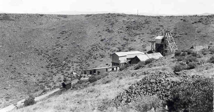
Richinbar Mine - Photo from 1940 - Courtesy of Arizona Geologic Survey files

Tuesday, January 8, 2013

150th Anniversary of the Arizona Territory

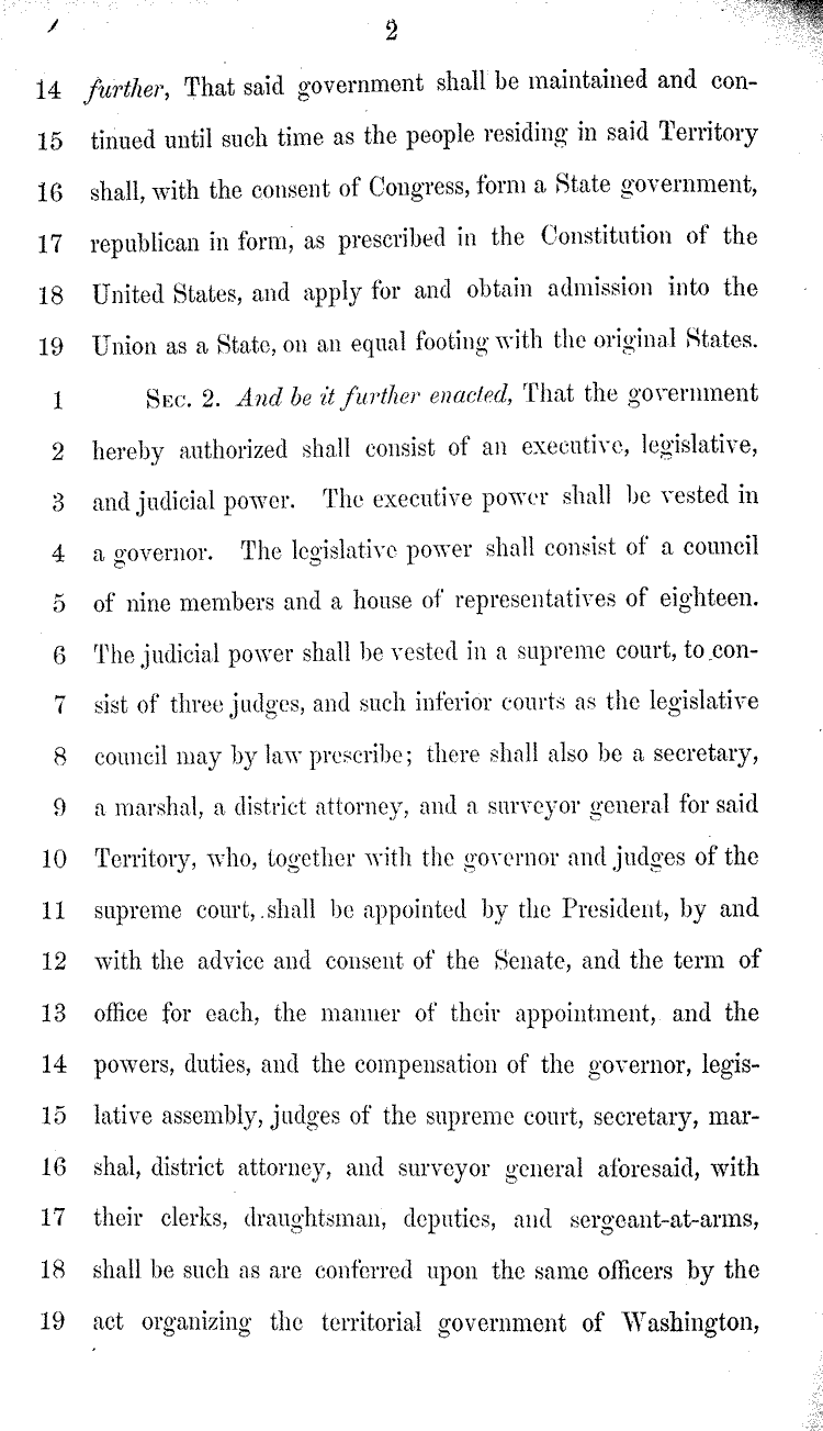
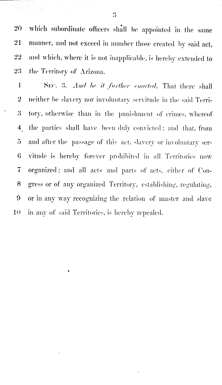
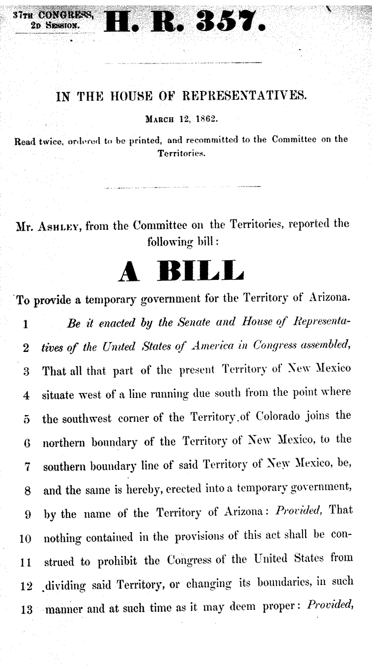
I am continuing to research the Territorial history of Arizona. February 2013 marks the 150th Anniversary of the formation of the Arizona Territory. The Arizona Territory was formed in the midst of the Civil War. The South claimed the southern portion of Arizona as part of the Confederacy. President Lincoln signed this bill into law on February 24, 1863. Prescott was chosen as the original Territorial Capital, despite the fact that Tucson was a more established town. Tucson was located in the disputed portion of the Territory. Here is a link to the Library of Congress: http://lcweb2.loc.gov/cgi-bin/ampage?collId=llhb&fileName=037/llhb037.db&recNum=1985

Tuesday, December 11, 2012

Original Phoenix Townsite Map

Thomas Edwin Farish's 8-volume History of Arizona was published between 1915 and 1918. Volume 6 describes the early days of the Salt River Valley and the formation and development of the Phoenix townsite. "When the commissioners appointed by the Salt River Valley Association received their instructions, they employed in the month of November, Captain Wm. A. Hancock to survey and plan the townsite upon the half section selected for that purpose, and by the 23rd of December, 1870, a sufficient number of lots had been surveyed to enable the Town Commissioners to hold a sale and so procure funds enough to prosecute the work of surveying. This work was necessarily slow, and frequently lagged for the want of funds, as money was very scarce, but by Autumn of 1871, the last lot had been surveyed and the Hancock map furnished, showing a town site one mile in length by half a mile in width, divided into ninety-eight blocks. These city founders laid out the original townsite of Phoenix so as to provide for a large and populous city in the future. Washington, the main street running east and west, was one hundred feet wide, as was also Jefferson, the first parallel street to the south, and Center, the principal cross street, while all other streets were made with a width of 80 feet. With few exceptions blocks were laid out three hundred feet long, 12 lots, 50x137½ feet each, to the block, with a 25 foot alley running through most of the squares. The first lot sold was that on the southwest corner of Washington and Montezuma (now First) streets. It was bought by Judge William J. Berry of Prescott, for $104, while the adjoining lot to the south brought $40. The opposite corner, where Berryhill's store is now located, was sold to Captain Hancock for $70. It was resold to Ellis & Company a few years later for $8,000. The two lots first mentioned, Nos. 1 and 2 in Block 22, which at one time also belonged to George D. Kendall, an early contractor and carpenter, are to-day covered by a portion of what is called the Irvine Block, built in 1879, by Edward Irvine, an early resident of this city, but lately deceased, while upon the Hancock lot, No. 2 in Block 21, on the opposite side of Washington street, was erected in 1889 the Anderson Building, which is now occupied by the Berryhill Stationery Store and the Baswitz Cigar Company." Thanks to Brad Hall for posting a copy of the Phoenix Townsite map. I posted the location and description of some of the first buildings constructed in Phoenix. According to Farish, "At this time [1870's] all the buildings were of adobe. Lumber was exceedingly scarce and expensive, the little reaching the valley coming from Prescott."

Thursday, November 29, 2012

Scheduled Appearance Update and New Article in True West Magazine

I am scheduled to perform my original songs and stories at the Rustic Cafe on this Saturday night:
Dec 8 - 6:00 - 6:30 Rustic Cafe - 20811 N Cave Creek Road, Phoenix (2 blocks north of 101)
I will be performing several new songs.  My newest song (The Mexican Outlaws) is in memory of Nicholas Ivie, the US Border Patrol Officer who died on Oct 2 near the town of Naco, Arizona.  Another song (The Ballad of the Rocking AD) is inspired by the work of Allen Dutton, the muti-talented artist who has written about and photographed many of Arizona's historic locations.  Mr. Dutton's good humor and intellectual curiosity has inspired the creative spirit of all his work:  photographs, painting, writing, sculpture, and teaching.

I am pleased to announce that True West Magazine will be publishing my article about the life of William Porter Jones, a young man who left his family in rural Missouri to search for gold in the western mining camps from 1858 to 1864.  His collection of letters were preserved by his family and donated to the Sharlot Hall Archives.  The letters tell the tale of a prospector who maintained his good humor and optimism, despite the danger and financial risks that he faced in his chosen occupation.  William Jones' journey took him from Pike's Peak Colorado, to Grass Valley and Virginia California, to Aurora Nevada, and finally to the mining camps along the Hassayampa River, Lynx Creek, and Big Bug Creek, Arizona.  His last letter home was post marked "Has-sa-amps Walker's Diggins" Jan 24, 1864.  Jones was  killed in June 1864 at the beginning of the violent conflict between the settlers and the Apache Indians.  My song "A Miner's Letter Home" was inspired by the life of William Porter Jones.

The True West Magazine will be on sale on Jan 1.  The title of the article is "War To The Death".  I hope that you enjoy the article.

Sunday, September 9, 2012

Military Map - mid 1860's - Prescott - Ft Whipple and Vicinity


Historic maps provide a window into the exploration and development of an area.  This undated map (probably 1864-65) is one of the first maps prepared by the U.S. Army to record the rivers and settlements of the Bradshaw Mountain region.  Previous historic maps, going back to the Spanish colonists do not show this level of detailed topographic features and trails.  

Joseph Walker, with the aid of Jack Swilling, led his small party of prospectors and adventurers into the Arizona Territory in 1863.  They travelled through New Mexico, and entered Arizona from the southeast, followed the San Pedro River north to the Gila River, and then travelled west to the mouth of the Hassayampa River.  They followed the Hassayampa River north, past present-day Wickenburg, and up the pine-covered slopes of the Bradshaw Mountains.  They discover placer gold deposits along Lynx Creek, several mile southwest of Prescott.

Although this is a small portion of the original map, it demonstrates the importance of rivers in the selection of travel routes and settlement locations in the Arizona Territory.

The townsite of Prescott, Fort Whipple, and Bowers Ranch are located along Granite Creek.  
The stamp mill is located along an unnamed creek.  The network of trails and roads follow the path of the creeks.  Fort Whipple was created by the U.S. Army to provide protection to the prospectors and pioneers who settled in Prescott and outlying areas.

This map is included in the Military Map Collection at the National Archives.  Many thanks to Jack Carlson for taking this digital photo of the map and providing it to me to support my research.  Jack Carlson is the author (along with Elizabeth Stewart) of several books about the hiking trails and history of the Superstition Mountains.  Check out his website for more information:  www.clearcreekpublishing.com


Tuesday, June 19, 2012

Sharlot Hall Folk Arts Festival - Prescott Courier Photo

Thanks to Bob Sanstedt, who added his fine banjo playing to back up my historic and mining songs.  He sang a few of his favorite songs and played some banjo instrumentals.  Our photo appeared in the Prescott Courier.

Thanks to Jody Drake, Curator of Education at Sharlot Hall Museum, for setting up a p.a. system for my use on Saturday morning.  The Sharlot Hall Museum provides a unique venue for the Arizona folk music community to entertain and educate the public.

Monday, June 11, 2012

North Star Mine Powerhouse - Grass Valley, Californa

I visited the North Star Mine Powerhouse in Grass Valley, California in May.  Gage McKinney, a local mine historian, recommended that I include this site during my tour of the area.  It is a small museum that contains many working examples of historic mining technology.  The 30-foot Pelton Water Wheel is the highlight of the exhibit.  I included three photos, since the wheel was too large to fit in one photo.  The second photo shows the tour guide to give some perspective to the scale of the wheel.

The tour guide explained that the Pelton Water Wheel was invented in the 1870's.  Each scoop is divided in two equal sections (see last photo for a good view).  According to the tour guide this design transfers more energy to the water wheel than traditional waterwheels.  He was proud to report that he saw a Pelton Water Wheel among the massive hydro-electric generators at Hoover Dam.  

The museum display includes one of the only working Cornish Pumps in the world.  Cornish Pumps were designed to pump large volumes of water from mine shafts.  

This small museum is rich in mining history, but does not appear to attract a large amount of visitors.   It is worth your time to check it out if you are visiting the Grass Valley area. 

 North Star Mine Powerhouse Historic Landmark


30 foot Pelton Waterwheel


Smaller Pelton Waterwheel showing the divided scoops

Cornish Pump 


Tuesday, June 5, 2012

Sharlot Hall Folk Arts Festival - History Meets Music

I had an enjoyable day on Saturday at the Sharlot Hall Folk Arts Festival in Prescott.  I participated in the Gold Panning area by telling historical stories and singing songs about the early days of Arizona's settlement.  We were fortunate that Jack Light, an expert mining geologist, led the gold panning activities.  We can't say for sure, but it looked like a lot of children went home with packets of gold dust.

I sang one of my songs, "The Hassayamper Song" that pays tribute to the men (Pauline Weaver, Joseph Walker, and Jack Swilling) who led the first two parties of pioneers and prospectors up the Hassayampa River in 1863 in search of gold.  Pauline Weaver led a small group of men, including Henry Wickenburg and Abraham Peeples, north from Yuma along the Colorado River, east along Bill Williams River and Date Creek.  It was there that they discovered the rich placer gold deposits at Rich Hill, and along Antelope and Weaver Creeks.

It was especially appropriate that I sang "The Hassayamper Song" since Pauline Weaver's gravesite is located at the north entrance to the Sharlot Hall grounds.  The plaque on his granite boulder headstone reads as follows:

Pioneer - Prospector - Scout - Guide
Trapper - Fur Trader - Empire Builder - Patriot
Pauline Weaver, truly a great man
Born in Tennessee in 1800
Died at Camp Verde June 21, 1867

He was born, lived, and died on the frontier of this country, always in the ever advancing westward move of civilization and was the first settler on the site of Prescott.  He was descended from the best blood of the white man and the native american, and his greatest achievement was as peacemaker between the races, understanding as few ever did the true hearts of the two peoples.