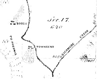
John Townsend is the subject of one of my songs, and continues to be the focus of my historical research. Please refer to my prior blog posts for background information about John Townsend. I have learned some important information over the past two years about one of Arizona's more interesting Pioneers. I have collected and read material housed in the archives of Arizona libraries and museums, online historic newspaper articles, secondary sources (journals, local and regional histories), and historic maps. Among other things, I have determined the location of the Townsend Ranch. Historic newspaper articles and letters refer to ranches, assuming that their location was common knowledge (i.e. Woolsey Ranch, Boggs Ranch, Townsend Ranch). As stated in the lyrics of my song, the Townsend Ranch was 40 miles from Fort Whipple, along the Agua Fria River. This was a dangerous place to live between 1865-1880. Pioneers in this area were isolated from the protection of Fort Whipple, while occupying a traditional travel route and rest area used by the Apache Tribe.
Here is an excerpt of a historic land survey map issued in 1874:
It is fortunate that the surveyor listed the owner/tenant for each ranch included in the survey. The Boggs brothers, Theodore and John, will be the subject of future blog posts.
Thanks for the history! good to knowLand Surveyor CV Template
ReplyDelete